Skip to main content
Home
Palestine in Ten Maps
Historical Maps
Maps +
Back to edmaps.com
Maps of Israel and Palestine on Other Sites
MAP COLLECTIONS AND ATLASES: ISRAEL AND PALESTINE
Atlas of the Historical Geography of the Holy Land
(George Adams Smith)
Blank and Outline Maps of Israel
(d-maps.com)
Changing Maps of Palestine/Israel
(The Israeli Committee against House Demolition)
Digital Archaeological Atlas of the Holy Land
Historical Maps of Israel & Palestine
(American Geographical Society Library Digital Map Collection)
Historical Maps of Israel and Palestine
(David Rumsey Map Collection)
Historical Maps of Palestine
(Geographic Guide)
Israel: Historical Maps Collection
(Library of Congress)
Israel’s borders explained in maps
(BBC)
La Palestine en cartes, citations, faits et chiffres
(Le Monde diplomatique)
Middle East Maps
(Dr. Michael Izady)
Maps of the Islamic Middle East
(Princeton University)
Maps and Atlas of Palestine
(Palestine Land Society)
Old Maps of Israel/Palestine
(oldmapsonline.org)
Ottoman and Arab Maps of Palestine, 1880s-1910s
(midafternoonmap.com)
Palestine Maps
(OCHA -- U.N. Office for Coordination of Humanitarian Affairs)
Palestine Maps Before and After Nakba 1948
(PalestineRemembered.com)
Palestine Open Maps
The 20th Century Rebirth of Israel Pictured in Maps
(Focus on Jerusalem)
The Atlas of Palestine, 1917-1966
(Dr. Salman Abu Sitta)
PALESTINE BEFORE 1948
Palestine in the Time of Jesus, 4 BC-30 AD (including the Period of Herod, 40-4 BC)
Palestine under the Herods
Crusaders States, c. 1190
Western Asia at the time of Saladin, 1190
(Lane Poole, Historical Atlas of Modern Europe, c.1900)
Palestine: The first Zionist colony in Palestine, 1878
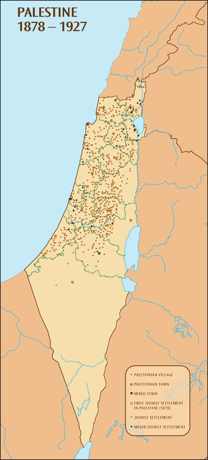
Palestine, 1878-1927
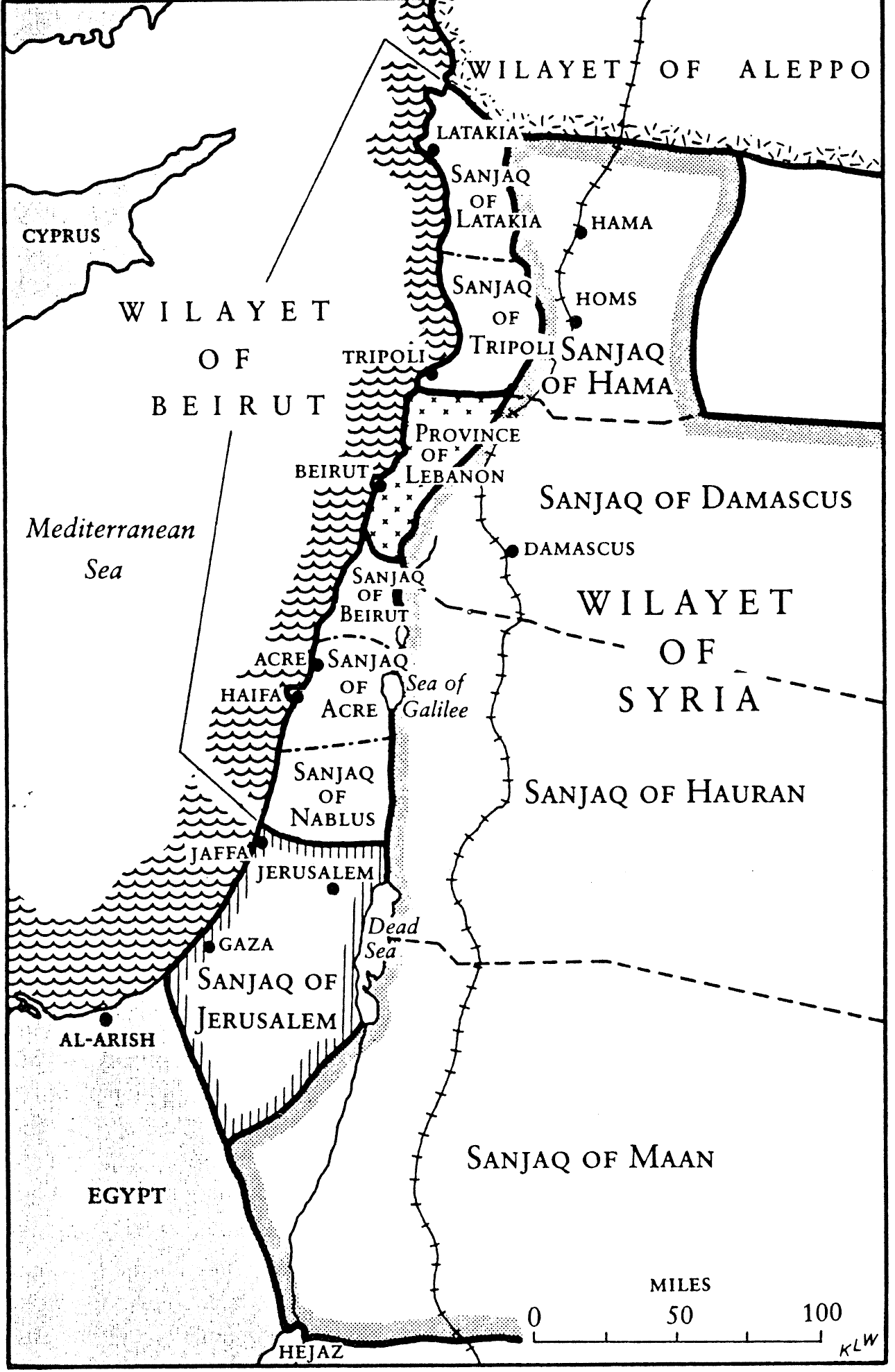
Ottoman Levant, 1890s: Administrative Division
Egypte, Palestine, Syrie, 1913
(Garnier)
Ottoman Levant (Jerusalem, Beirut, Mount Lebanon, etc.) before 1914: Administrative Division
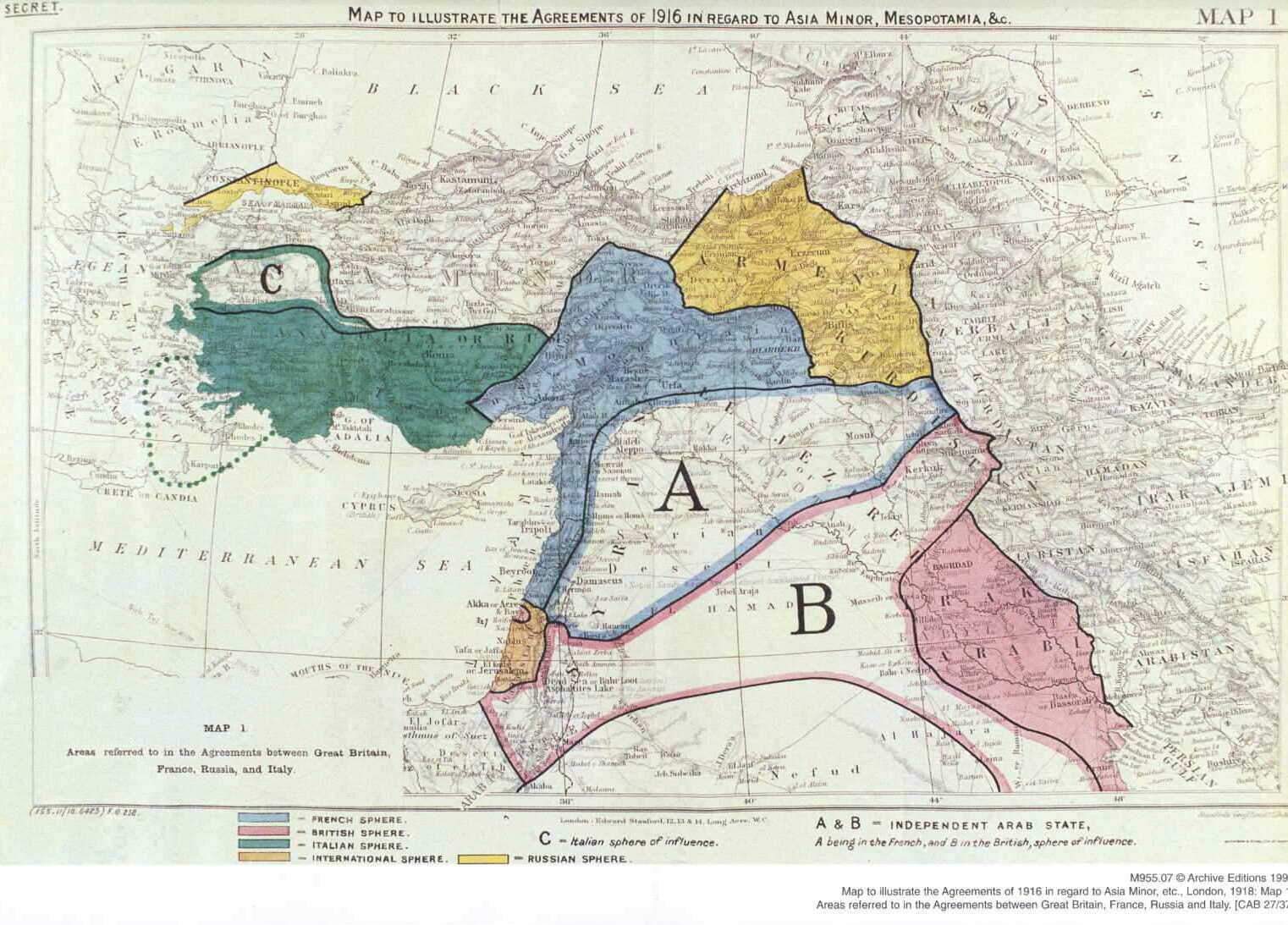
The Agreements of 1916 in Regard to Asia Minor, Mesopotamia, & Co.
Egypt and the Near East, 1918
(Daily Telegraph)
Strategical Map of Palestine, Syria and the Sinai Peninsula, 1918
(George Philip and Son)
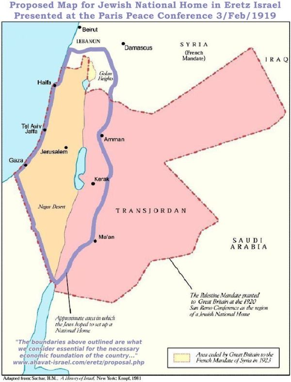
Proposed Map for Jewish National Home in Eretz Israel Presented at the Paris Peace Conference, 1919
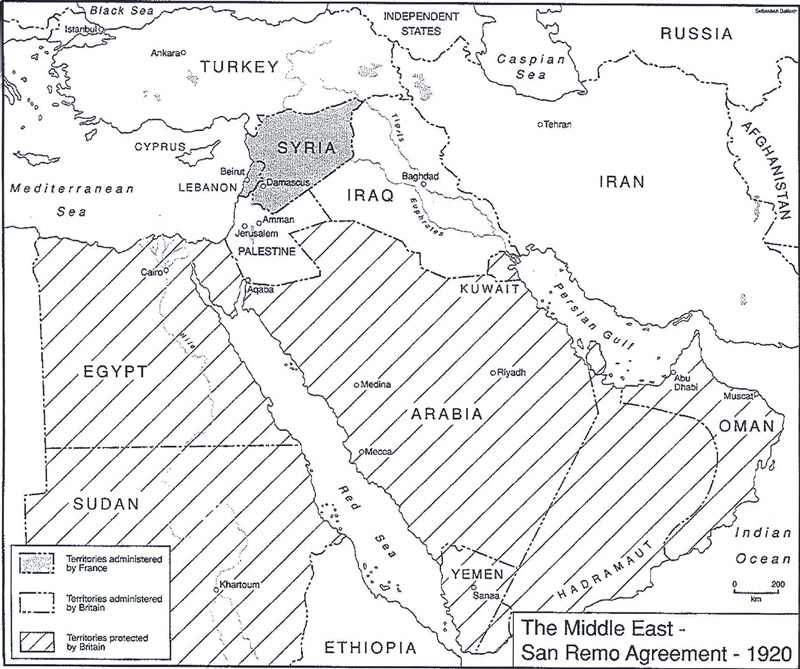
Middle East, 1920: San Remo Agreement Map
French Mandate in Syria, 1922
Palestine under the British Mandate, 1923-1948
Palestine 1945: Landownership in percentages by district
Palestine 1946: Districts and District Centers during the Mandate period
(PalestineRemembered.com)
Palestine 1948-1949: Very Detailed Map
Palestine 1948: Main Roads and Railways
Gaza Strip and Gaza District Before 1948
THE PARTITION QUESTION BEFORE 1948
The Birth of New Nations: Palestine, 1917
(New York Tribune)
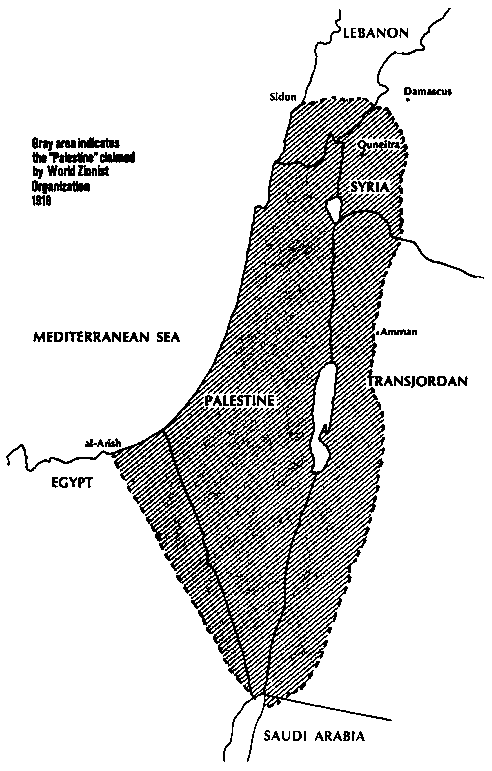
The Palestine claimed by World Zionist Organisation, 1919
(Jewish Virtual Library)
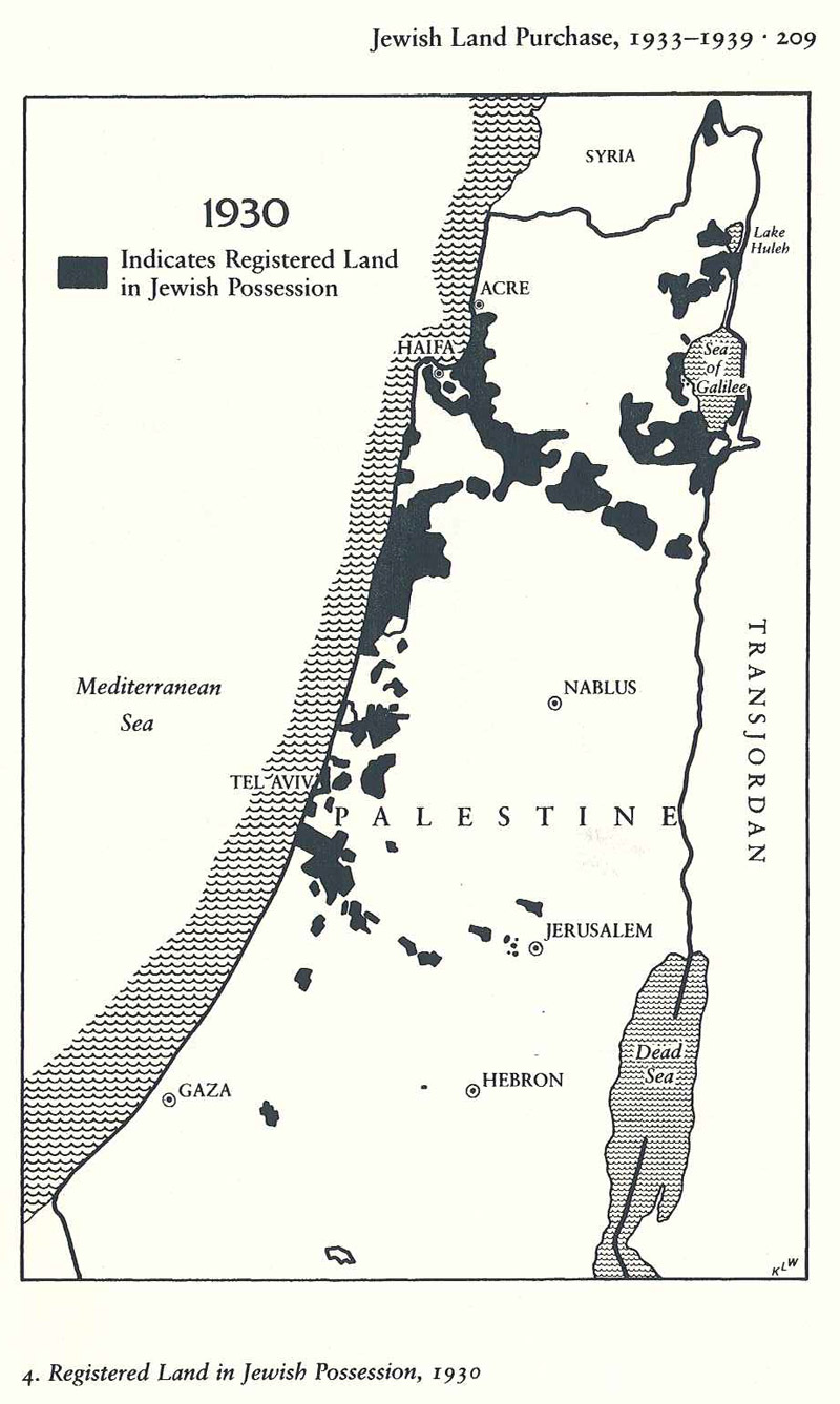
Map of the Registered Land in Jewish Possession, 1930
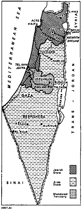
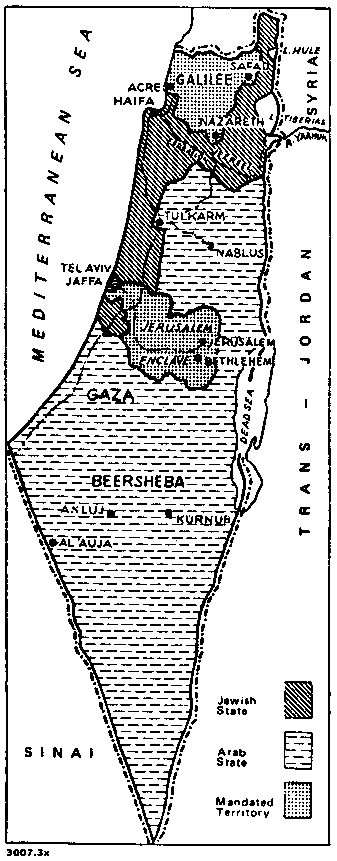
Peel Commission Partition Proposal, 1937
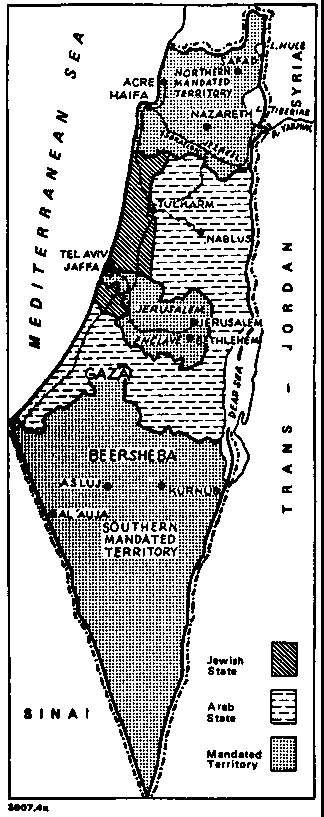
Partition Plan A - 1937
(Jewish Virtual Library)
Partition Plan B - 1938
(Jewish Virtual Library)
Partition Plan C - 1938
(Jewish Virtual Library)
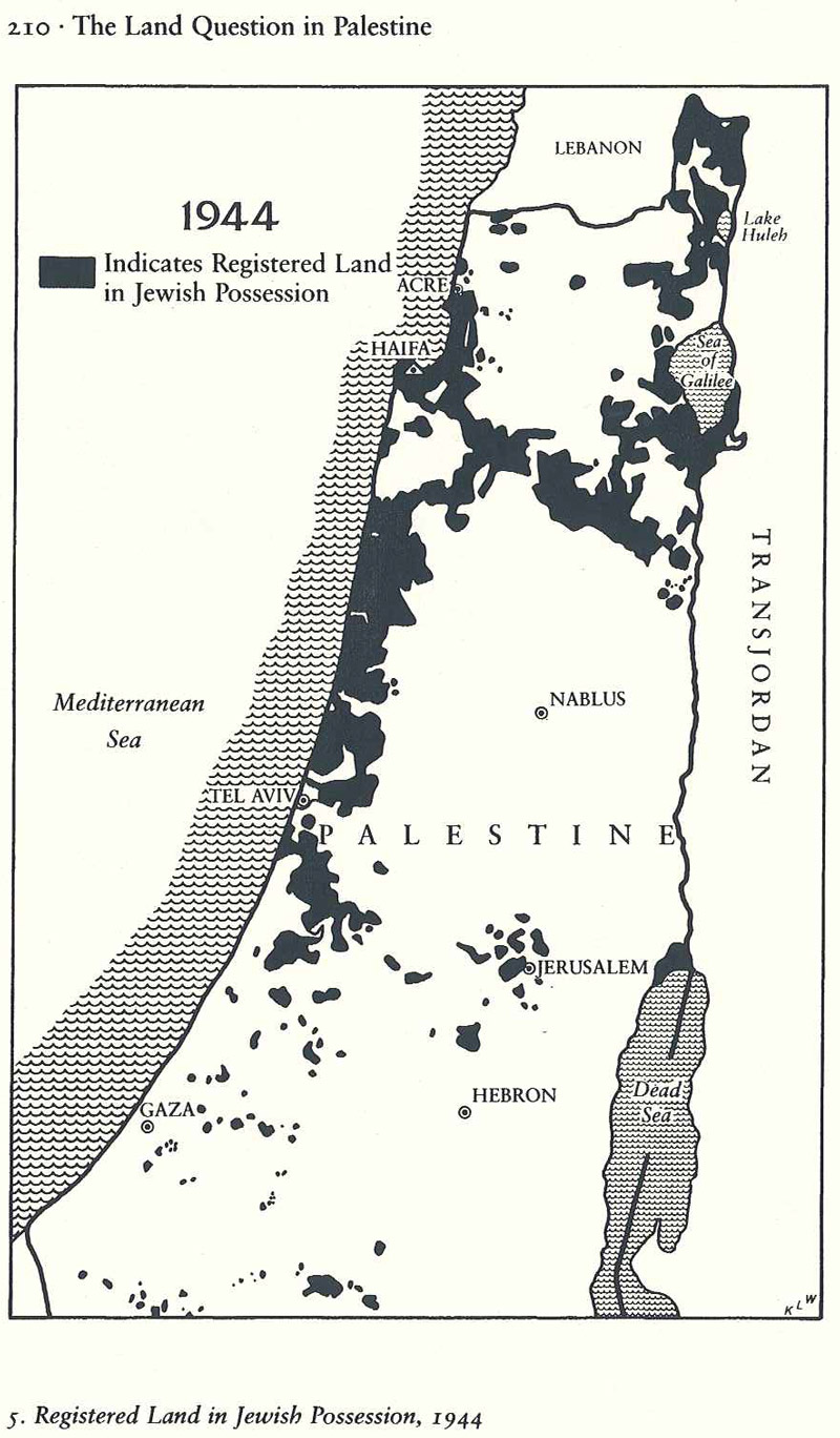
Map of the Registered Land in Jewish Possession, 1944
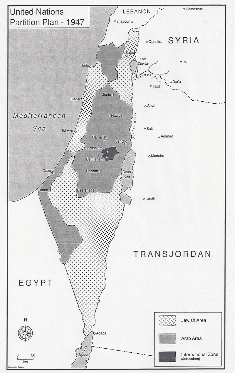
United Nations Partition Plan, 1947
Plan of Partition with Economic Union
The Second Bernadotte Plan
ISRAEL
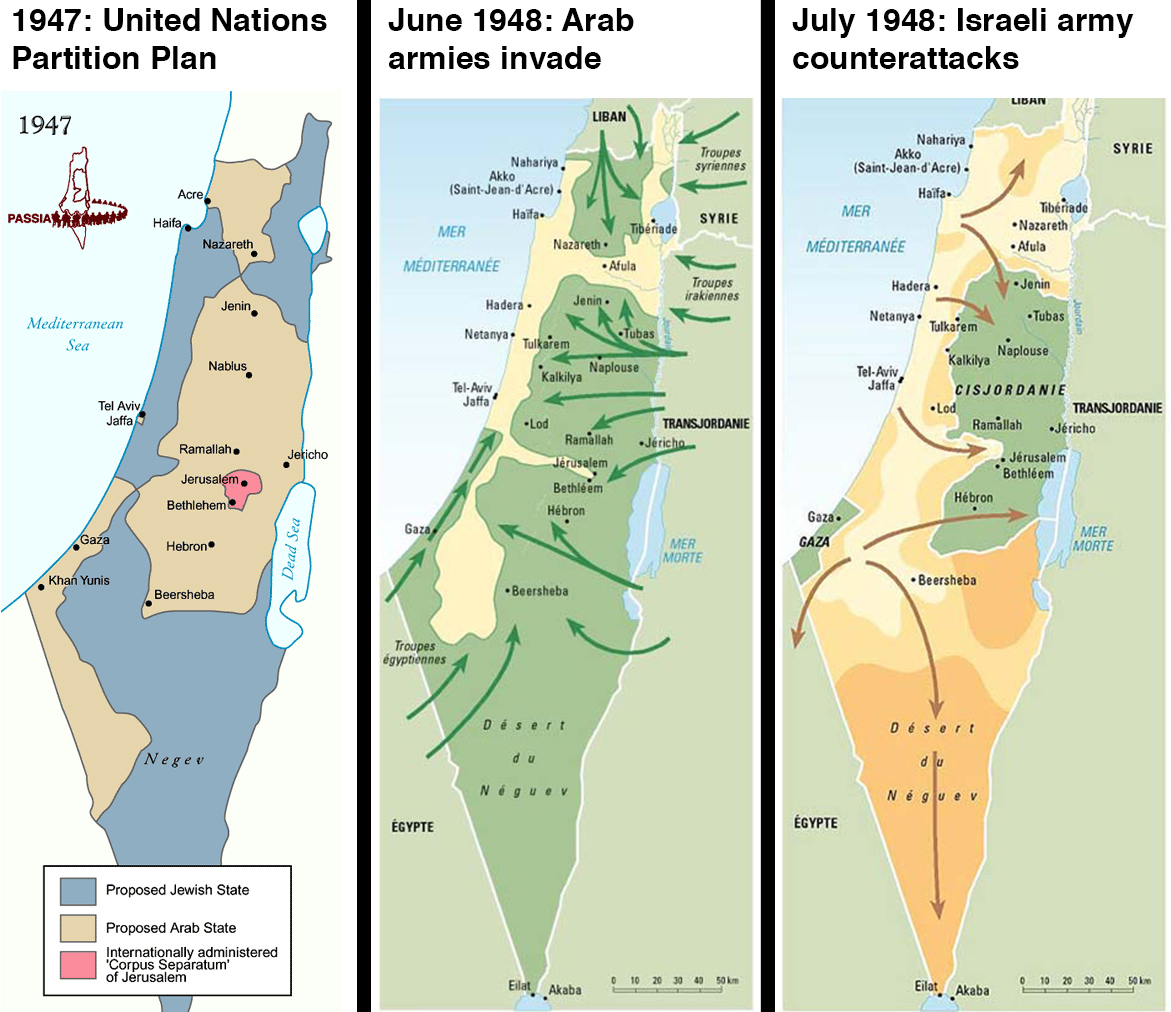
Israeli War of Independence
Israeli War of Independence: October 1948 Battles
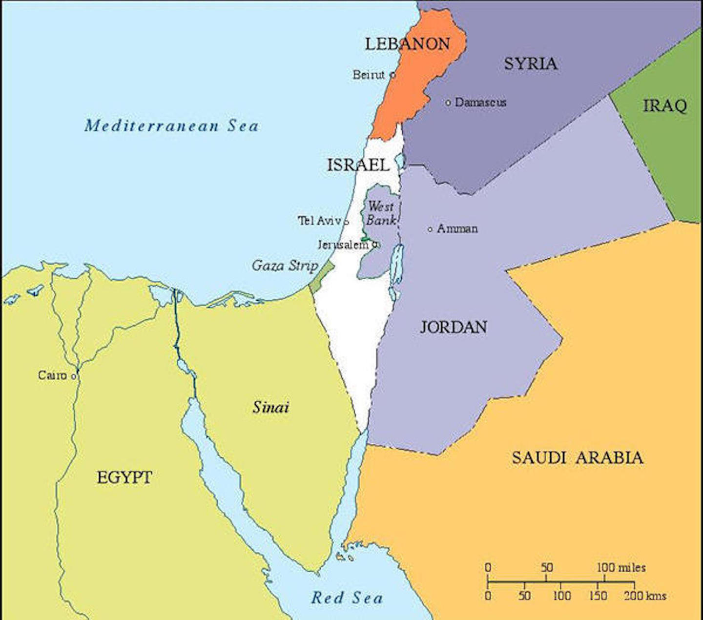
The Armistice Lines, 1949-1967
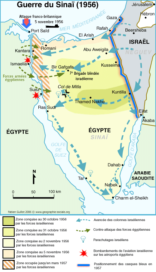
Guerre du Sinaï, 1956
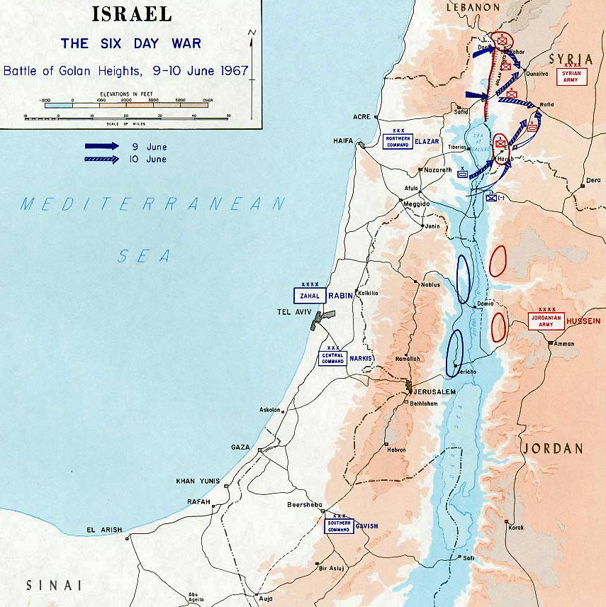
The Six Day War: Battle of Golan Heights, 9-10 June 1967
Israel and the Occupied Territories, 1967
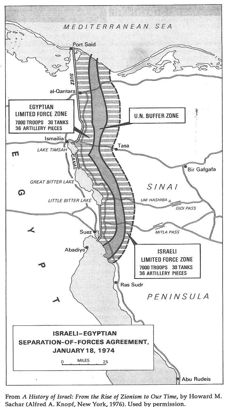
Israeli-Egyptian Separation-of-Forces Agreement, January 18, 1974
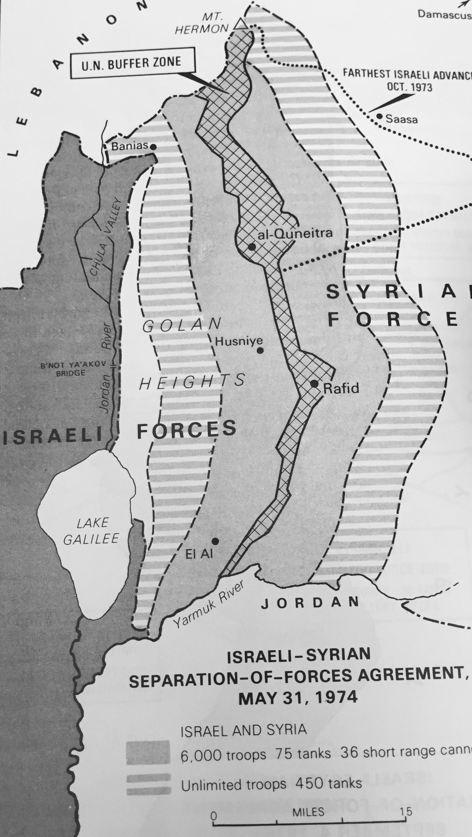
The Golan Heights after Israeli-Syrian Agreement, May 31, 1974
Israel’s Economic Map, 1978
Golan Heights:
Strategic Value of the Golan Heights
(Jewish Virtual Library)
Golan Heights:
La colonisation du plateau du Golan
Golan Heights:
Plateau du Golan
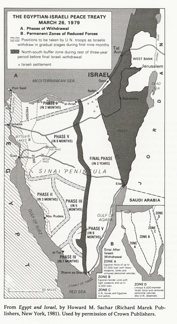
Israeli-Egyptian Peace Treaty, March 26, 1979
Golan Heights:
Israeli Settlements, July 1989
Gaza:
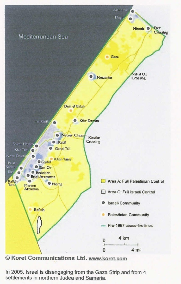
Map of the Jewish Settlements as of August 2005
The Israel Wine Map, 2013
(wineisrael.com)
ARAB PALESTINE AFTER 1948
Palestine M
aps Before and After Nakba 1948
(PalestineRemembered.com)
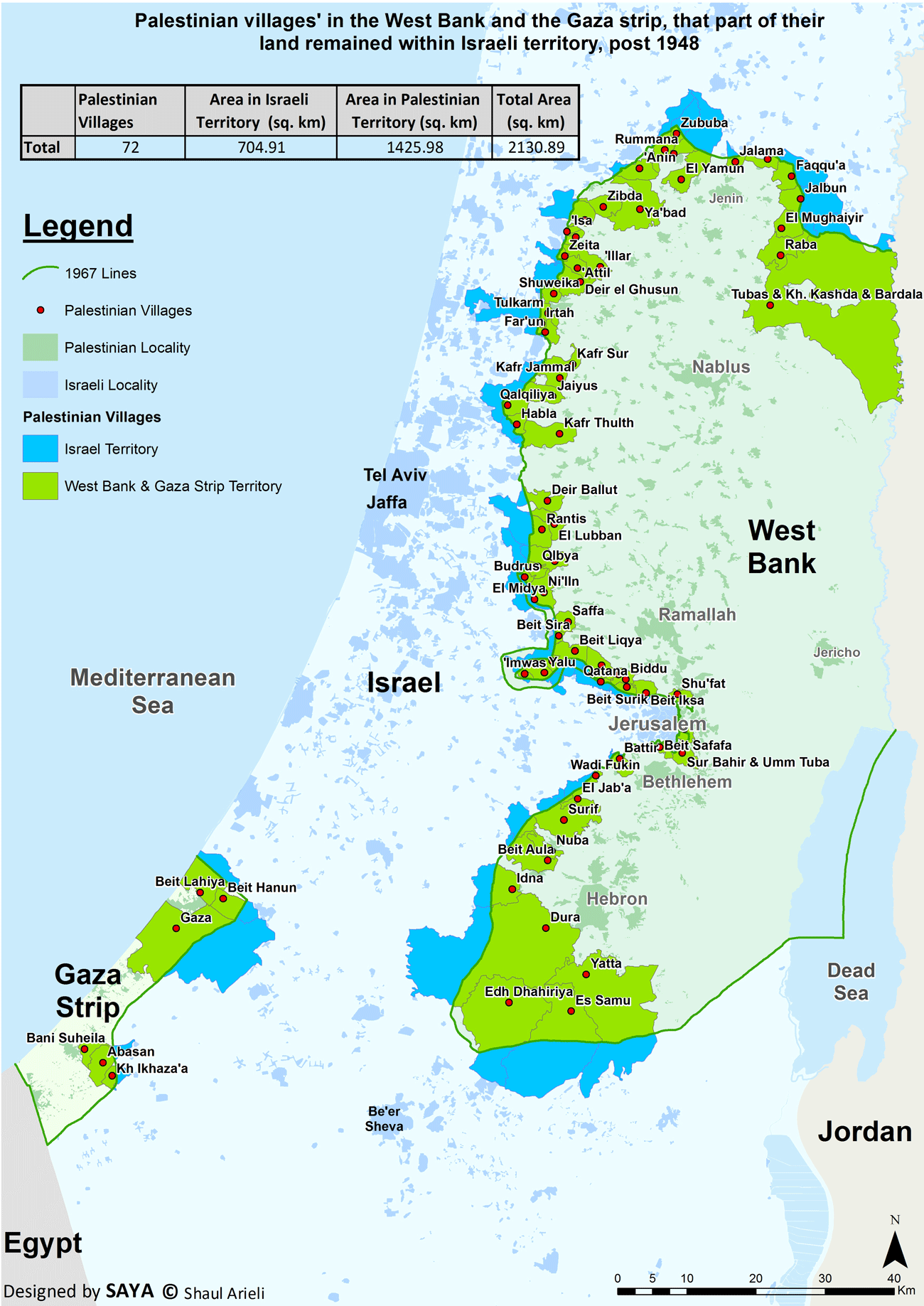
Palestinian villages in the West Bank and the Gaza Strip, that part of their land remained within Israel post 1948
The Effects of the Israel-Jordan Armistice Line of 1949-1967 on Arab Village Lands
(Jewish Virtual Library)
A FATAH Map of Palestine, 1978
(Al-’Asifah)
Israeli Settlements in the West Bank, September 1983
A FATAH Map of Palestine, circa 1985
(1) (Al-’Asifah)
A FATAH Map of Palestine, circa 1985
(2) (Al-’Asifah)
Israeli Settlements in the Gaza Strip, December 1993
West Bank and Gaza Governorates According to Palestinian National Authority, 1995
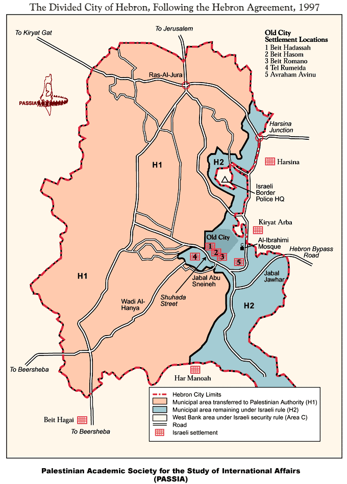
The Divided City of Hebron, Following the Hebron Agreement, 1997
La Cisjordanie - Cisjordan, 2000
(Le Monde Diplomatique)
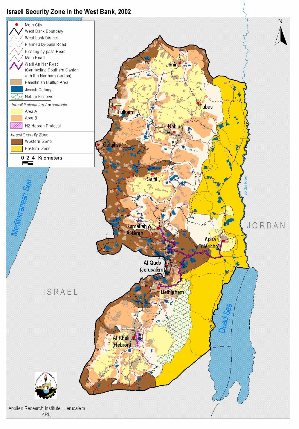
Israeli Security Zone in the West Bank, 2002
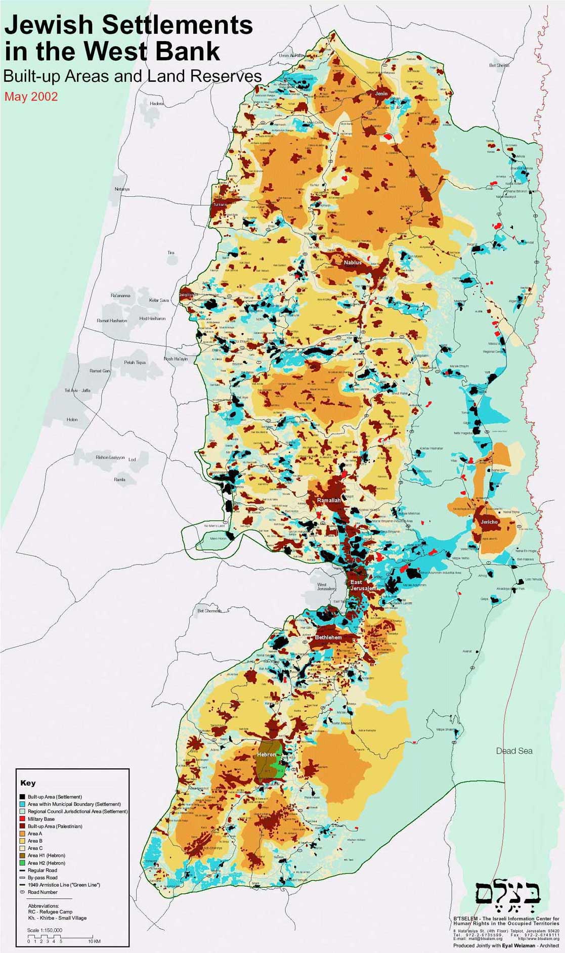
Jewish Settlements in the West Bank, May 2002
(Jewish Virtual Library)
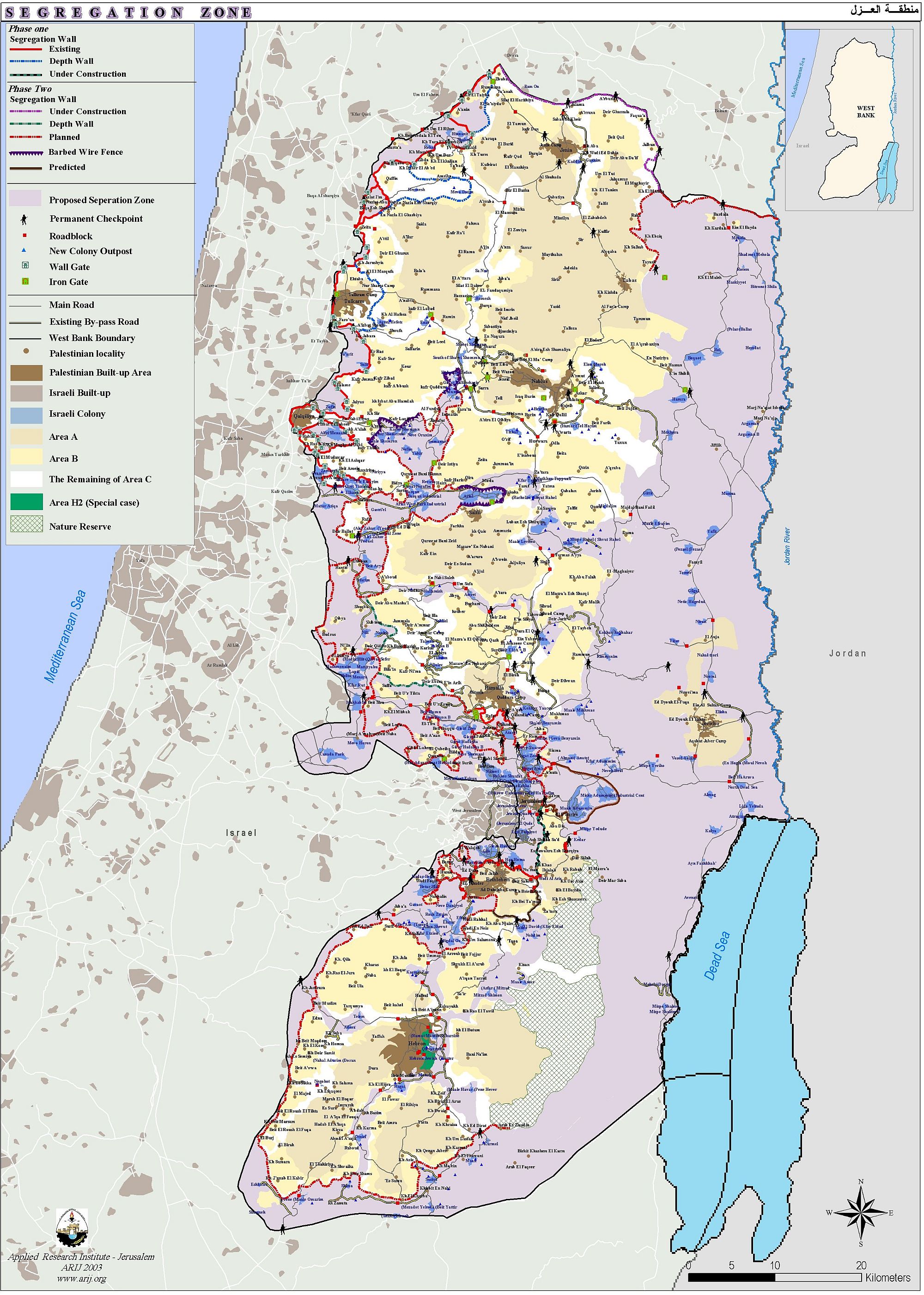
West Bank Segregation Zone, 2003
West Bank Population Map, October 2005
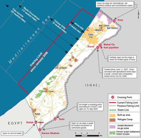
Gaza Strip, 2009
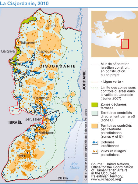
La Cisjordanie - Cisjordan, 2010
Occupied Palestinian Territory, December 2011
(United Nations OCHA)
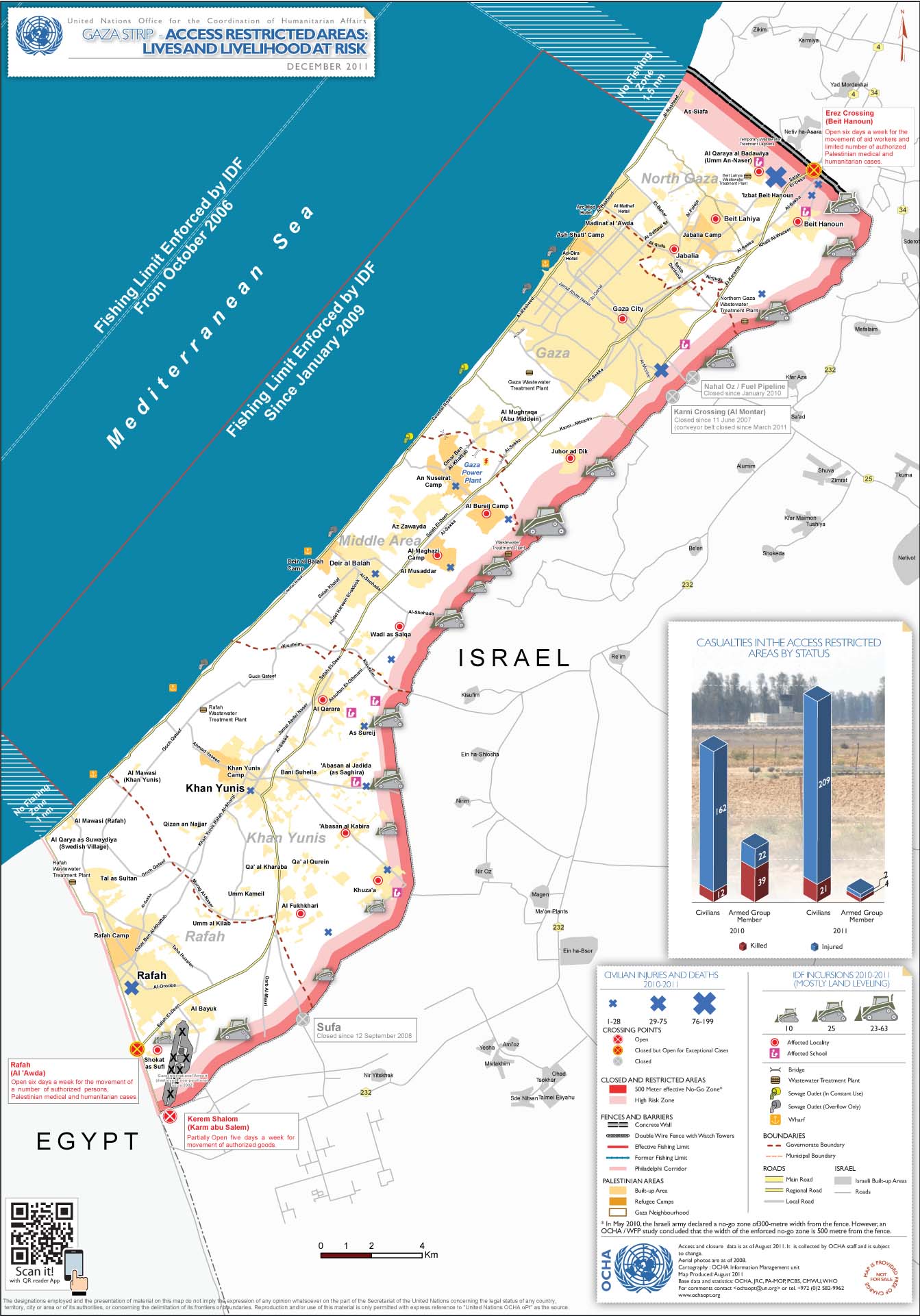
Gaza Strip: Access Restricted Areas - Lives and Livehood at Risk, December 2011
(United Nations OCHA)
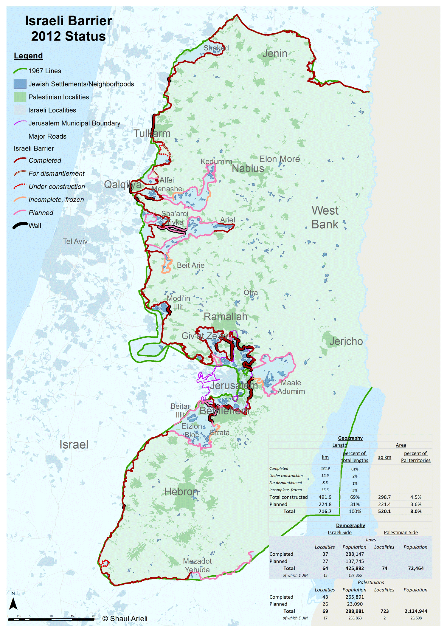
Israeli Barrier 2012 Status
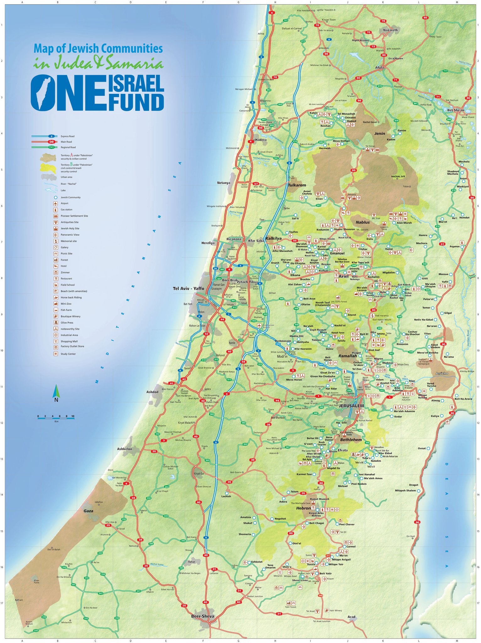
Map of Jewish Communities in Judea and Samaria, 2012
(One Israel Fund)
Palestinian Communities at Risk of Israeli Settler Violence, September 2012
(United Nations OCHA)
Interactive Map of Palestine
(West Bank and Gaza Strip) (Btselem)
PEACE, BORDERS, TERRITORIES...
Palestine 1946: Landownership by district showing percentages of Jews and Palestinians
Carte du territoire palestinien
(CBC/Radio-Canada)
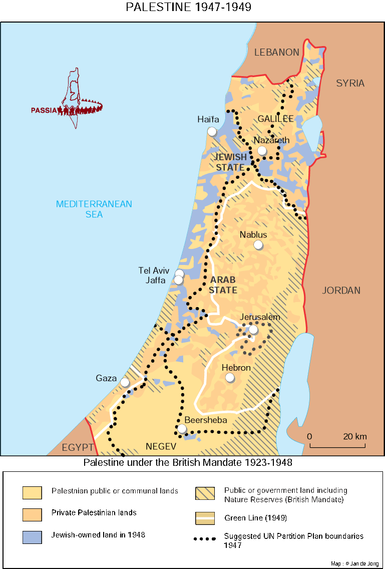
Palestine 1947-1949
The Partition
(The Guardian)
The Partition of Palestine: 1947-1949
(Le Monde diplomatique)
City of Jerusalem: Boundaries Proposed by the United Nations, November 1947
Jerusalem at War 1948
The Syrian-Israeli Frontier - Relevant Lines: 1923, 1949, 1967
(Jewish Virtual Library)
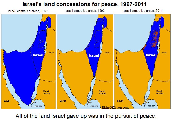
Israel’s Land Concessions for Peace, 1967-2011
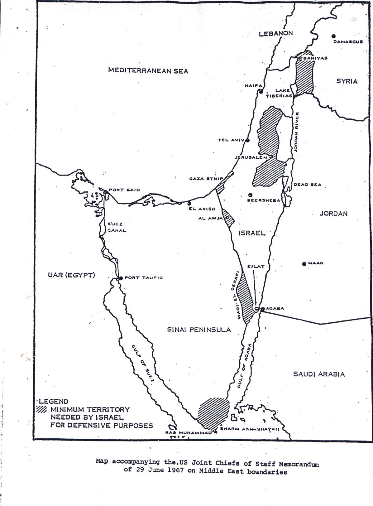
Minimum Territory Needed by Israel for Defensive Purposes (1967 Memorandum)
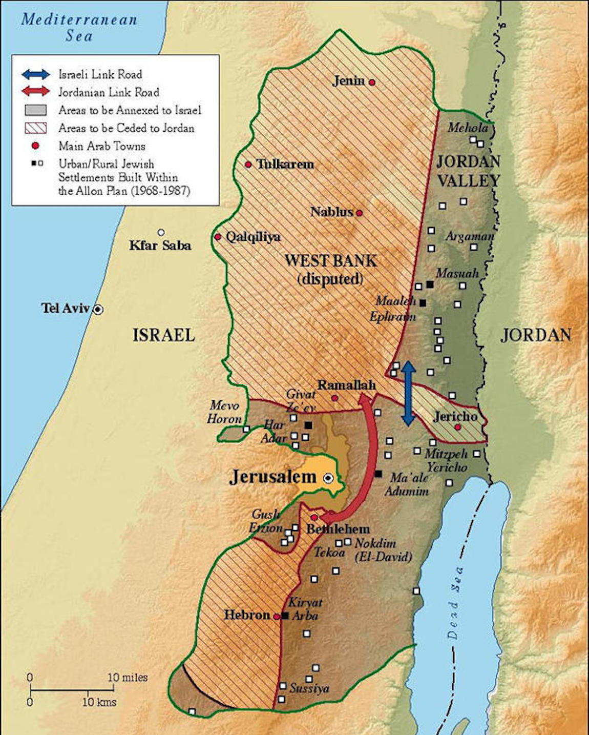
The Allon Plan, July 1967
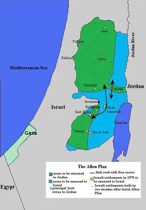
The Allon Plan, 1967
The Allon Plan, 1967
(Jewish Virtual Library)
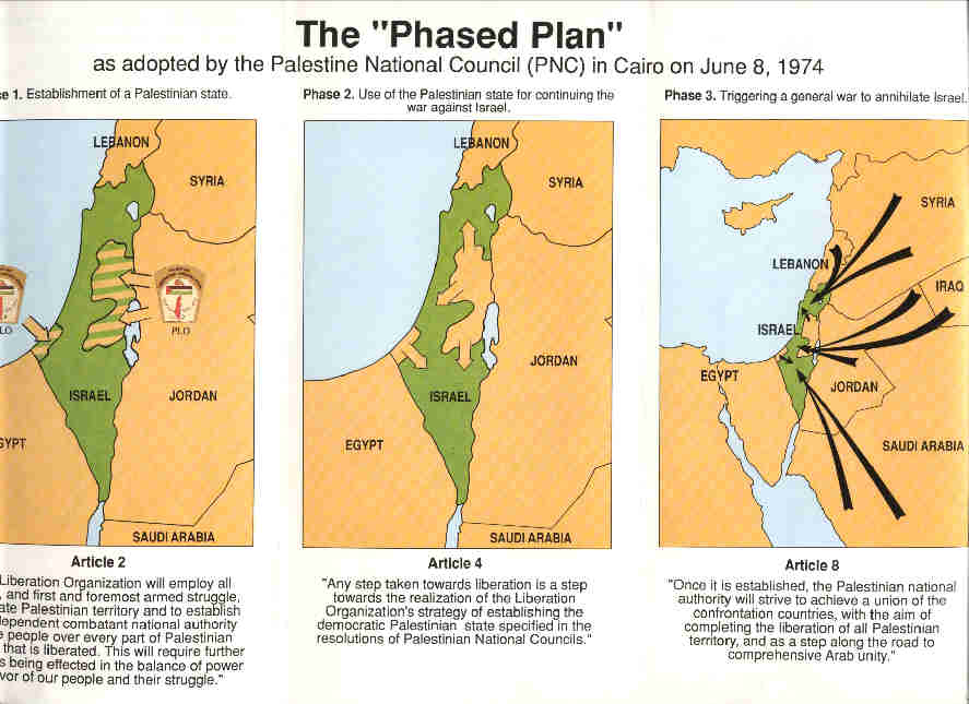
The Phased Plan as Adopted by the Palestine National Council in Cairo on June 8, 1974
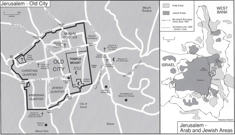
Old City of Jerusalem, 1988: Arab and Jewish Areas
Jerusalem, 1996
(Le Monde Diplomatique)
Oslo II Accords
(Washington Post)
Clinton’s Peace Plan, 2000
(Jewish Virtual Library)
Clinton’s Peace Plan, 2000
Israeli (Barak Gvt.) Proposed Territorial Settlement during the Eilat Talks, May 2000
(Yediot Aharonot)
Israeli Proposal to Palestinians and Syria on the Eve of the Camp David Talks, July 2000
Israeli Proposal for the West Bank Final Status Map at Camp David, July 2000
Israel’s Wall and Settlements (Colonies) in Occupied East Jerusalem, July 2005
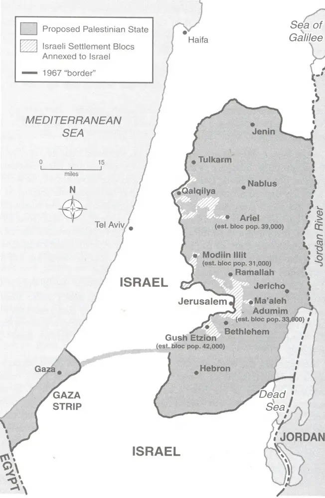
Projection of Israeli Proposal for Territory
(Al-Jazeera)
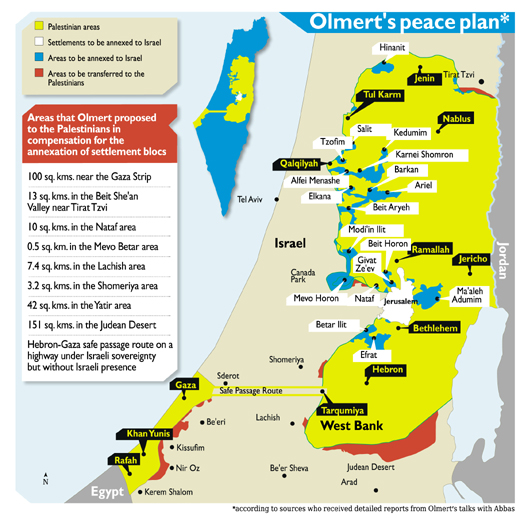
Olmert’s Peace Plan
Israel’s Strategic Vulnerability from the West Bank, 2008
(Jerusalem Center for Public Affairs)
Political Cartography of Palestine
(Leopold Lambert)
Trump Peace Plan Overlay on Settlements and Solutions
The Israeli-Palestinian Conflict in Maps
(Shaul Arieli)
Jordan Valley Map
(Netanyahu Plan 2019)
Netanyahu’s Jordan Valley Annexation Map 2019
(peacenow.org.il)
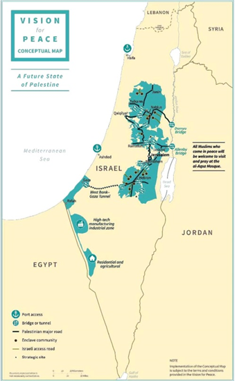
Vision for Peace Conceptual Maps
(Trump Plan 2020)
Vision for Peace Conceptual Maps
(Trump Plan 2020)

